Drone Flight
Control


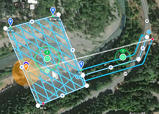
Customize and combine Grid, Crosshatch, or Linear Maps, easily enable terrain follow, set oblique angles, overlaps, and crabwalk.
View example
Cross Platform
Supported Drones and Devices
Use on Web, iOS, Android, and Remote Controllers with screens for DJI and Autel drones. One account for all devices and drones.
Learn more
Unlimited Possibilities
Automate Data Capture for Any Use Case and Industry
Capture data to create orthomosaics, point clouds, 3D models, and for inspections, site documentation, and videography. Perfect for flights in construction, energy, telecom, mining, property management, insurance, agriculture, film, public safety, education, and more.
Learn more
Limitless Customization
Link Missions Together and Automate Everything
Combine multiple mission components into a single unified mission, and automate every aspect, including all the drone and camera settings.